The European planning cockpit
for everything up to 10,000 ft.
European weather, vertical cloud & icing profiles, terrain and wire-strike hazards and live rescue traffic — with SERA-based IFR minima and EASA CAT/SPA.HEMS fuel and reserve logic. Built by European pilots, on European data.
Europe’s aviation planning solution for non-pressurised GA — rotary and fixed-wing — up to 10,000 ft.
No card required · 30-day trial · cancel anytime
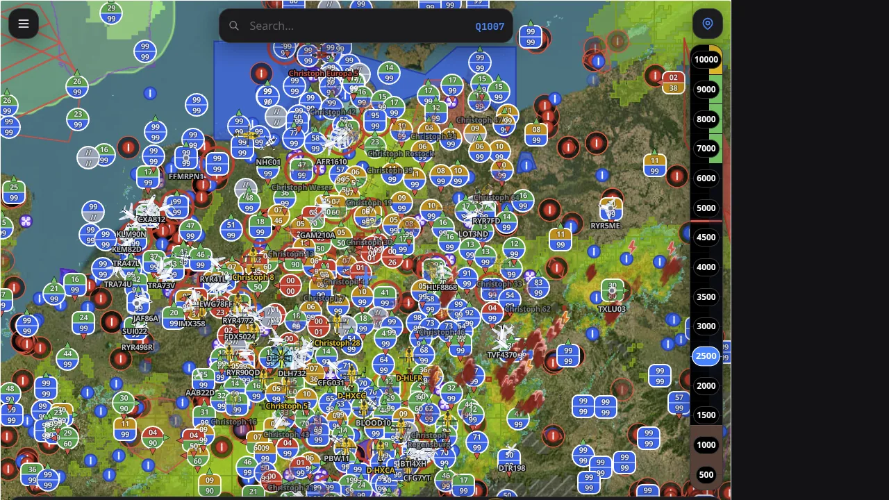
Live European rescue traffic — named fleet, reported altitudes, weather & lightning.
Made in Europe, for Europe.
Aus Europa, für Europa.
Most flight-planning apps are US products with Europe added on afterwards. LowLevel is the inversion — European by design: built on EASA and SERA rules, in European units, and fed first and foremost by European aviation authorities and open-data communities.
European rules first
Europäische Regeln zuerst
IFR minima computed from SERA, plus EASA Part-CAT and SPA.HEMS fuel and reserve logic — not FAA rules with a European skin. Part-NCO and fixed-wing coverage is still being built out, and the app marks what is not yet in scope rather than guessing.
European units
Europäische Einheiten
hPa, °C and metric ground distances, fuel in kg — with altitudes and speeds in ft and kt, exactly as EASA charts them. No unit-guessing, no US sectionals.
European data, first-class
Europäische Daten, erstklassig
Weather, airspace, obstacles, wires and traffic come from European authorities and European open-data communities. NOTAMs reach us as ICAO-format notices through an international NOTAM distribution service, not a European AIS provider — the one non-European link in the chain, and we would rather say so than leave it unsaid.
Built by European pilots
Von europäischen Piloten gebaut
Made in Darmstadt by Rotorsolutions for GA up to 10,000 ft — rotary and fixed-wing — across Europe. This site is in German and English; the app interface is English today, German next.
European data sources, built in
Coverage varies by layer and region. Airspace, aerodromes and live traffic are Europe-wide. High-resolution DWD weather leads in the German FIR and is expanding across the Alps. Obstacle and wire coverage is per-state — live today in Germany, Switzerland, Austria, France, Italy, Slovenia, Czechia, Estonia, Lithuania, Luxembourg, Spain.
Safety-critical layers — NOTAM, SIGMET/AIRMET, obstacles and wires, thunderstorm and low-visibility forecast, airspace and traffic — carry their own freshness signalling: when a source goes down, the last good data stays on the map but dimmed, under a source-down banner. Absence of returns never masquerades as clear conditions.
Used by HEMS Operators, Pilots, and Aviation Enthusiasts
Implementierung und Visualisierung von MET-Informationen
Vollständig konformLowLevel ist vollständig konform mit den EASA-Vorgaben zur Darstellung von Wetterdaten, um höchste operationelle Sicherheit in der Luftfahrt zu gewährleisten:
„Für die korrekte Implementierung und Visualisierung von meteorologischen Informationen in Systeme zur Anwendung in der Luftfahrt ist die Richtlinie Display of Meteorological Information (Acceptable Means of Compliance for Display of Digital Meteorological Information AMC-DWD-01) anzuwenden.“
Complete Mission Awareness.
Real screens from the app HEMS, SAR and police crews fly with — not mock-ups.
Live rescue-traffic & the named fleet
Every ADS-B, OGN and RescueTrack contact fused onto one map — named rescue helicopters (Christoph 77, Christoph Europa 5…), altitude on every target, weather radar and lightning. Filter to rotorcraft in a tap.
- ADS-B + OGN + RescueTrack fusion
- Named fleet, callsigns & equipment
- Weather radar + lightning overlays
- Altitude & vertical trend per contact
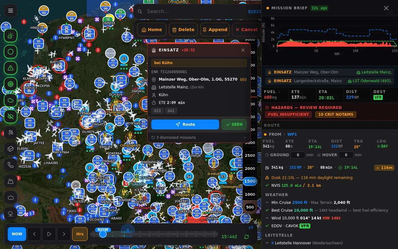
The whole mission brief — in one panel
Terrain and airspace as a vertical cross-section, fuel & weight, the NVIS window and daylight remaining — with hazards flagged before you lift: fuel-insufficient, 10 critical NOTAMs.
- Terrain / airspace vertical profile
- Fuel, W&B & endurance
- Hazard review: NOTAM · fuel · weather
- NVIS window + civil-twilight daylight
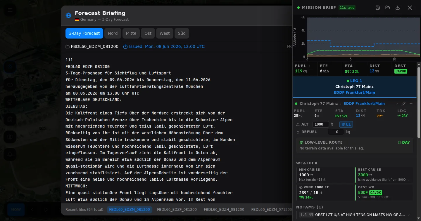
Low-level routing, icing-aware
Terrain-hugging low-level legs with per-leg minimum and best cruise for icing avoidance, obstacle NOTAMs surfaced (HT masts, unlit), and the German GAFOR 3-day briefing right alongside.
- Direct, low-level & hybrid-IFR routers
- Icing-avoidance cruise per leg
- Obstacle & wire-strike NOTAMs
- GAFOR / area-forecast briefing
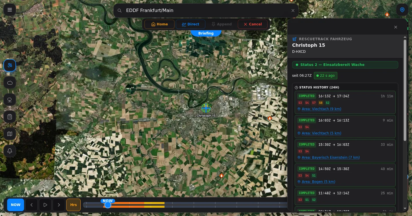
Live RescueTrack dispatch & BOS status
For approved operators: each aircraft’s live BOS status (Status 2 — Einsatzbereit Wache) with a 24-hour history by area, fused with its live position on the map.
- BOS / FMS status 1–8
- 24-hour status history by area
- Fused with live ADS-B position
- Leitstellen coverage modelled
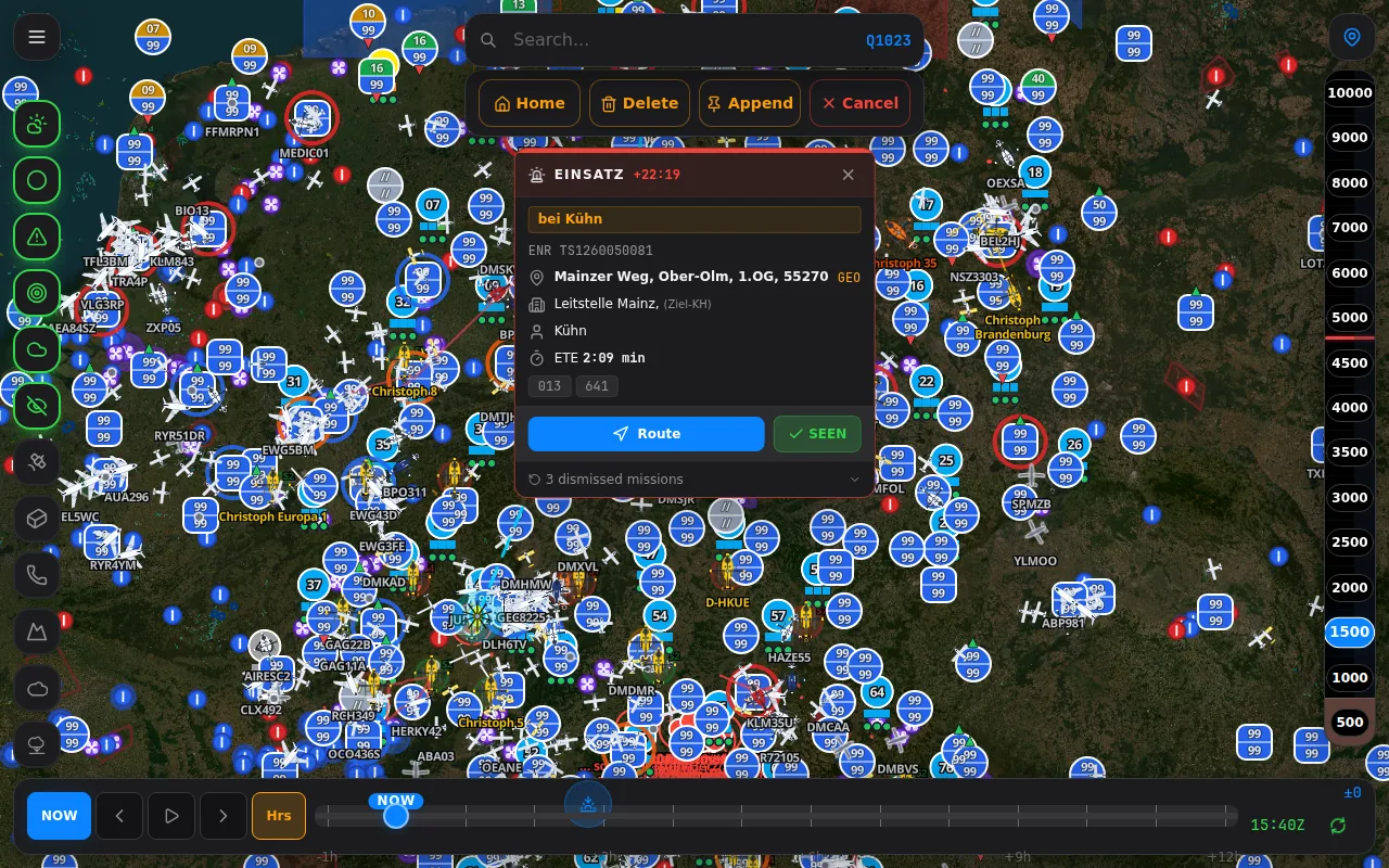
Dispatch, pushed straight to the glass
Incoming EINSATZ arrives on the map — scene address, target clinic (Leitstelle Mainz), ETE and a one-tap route — with a time-slider to scrub the last hours of the operation.
- Scene → launch → track
- Address, target clinic & ETE
- One-tap Direct-To route
- Time-slider replay
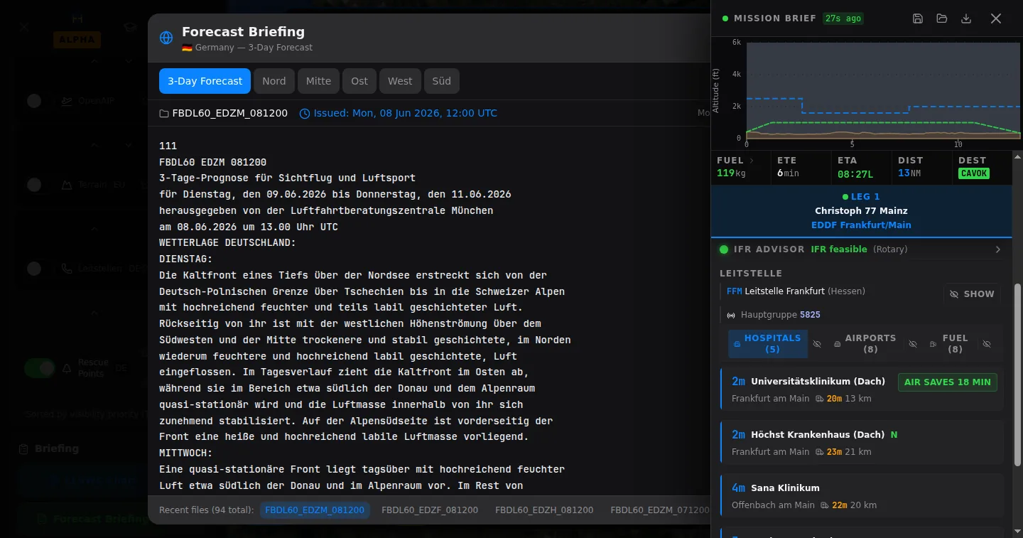
RescueTrack-aware ground routing
Hospital drive times and ground-vehicle ETAs (RTW, NEF) on real road routing — with active RescueTrack road closures fed in as a routing input, not just a map layer. When the fastest road runs through a closure, the time reflects the detour; “AIR SAVES 18 MIN” shows air vs ground at a glance.
- OSRM road routing, not straight-line
- RescueTrack road closures as a routing input
- Auto-detour around active closures
- Live RTW/NEF ETA + air-vs-ground
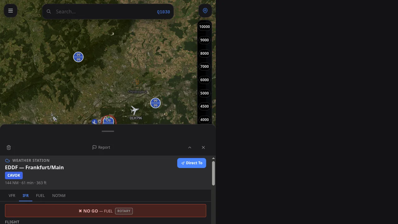
Instant go/no-go, per airframe
Every decision decoded to a clear call — a NO GO — FUEL for a rotary — computed against live weather, legal minima and your specific aircraft, on phone, tablet or the dispatch wall.
- Per-airframe rotary & fixed-wing
- Live weather vs legal minima
- VFR / IFR / fuel / NOTAM tabs
- Phone, tablet & desktop
100% Your Style.
Zero Clutter.
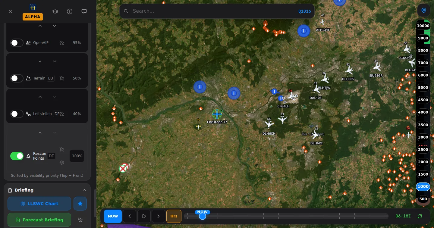
Every layer, opacity and priority is yours — OpenAIP, terrain, Leitstellen, rescue points — sorted top-to-front exactly how you want it. LowLevel is the only aviation app built to be fully morphable.
- Custom layer order
- Per-layer opacity
- Custom map icons
- Quick-action shortcuts
- Custom NOTAM filters
- Set home base
- Save workspaces
- Day / Night / NVG
Interactive Flight Deck
Click through the tabs to simulate the Vertical Profile view straight from the cockpit.
Decoded live by the same decoder the app runs — unrecognised groups are shown as-is, never guessed, and TEMPO/BECMG stays labelled as forecast. In the app this feeds the full weather picture, go/no-go and vertical profile.
Europe’s rescue fleet, live on one map.
Europas Rettungsflotte, live auf einer Karte.
The live spotter experience built right into your planning app — a named European rescue fleet in real liveries, history playback and alerts, on fused ADS-B and OGN coverage. All of it on the 5 € tier.
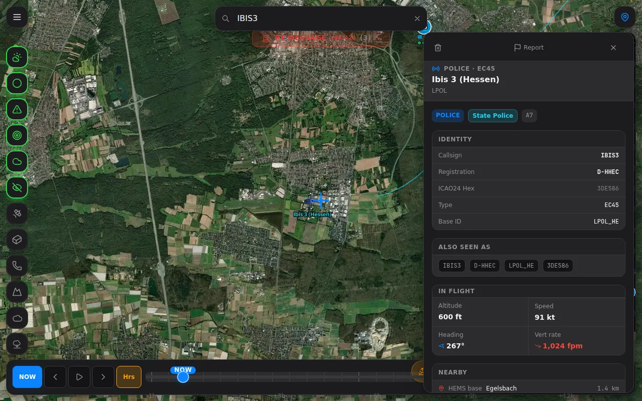
Live low-level traffic
Live-Tiefflugverkehr
ADS-B and OGN fused onto one European map — with altitude and vertical trend wherever the feed reports them, and rotorcraft-only filtering in a tap.
The named rescue fleet
Die benannte Rettungsflotte
Christoph, Rega, ÖAMTC and more — matched to registration and callsign, with home base and airframe type where we know them, and real livery artwork for the types we have drawn.
History playback
Verlaufs-Wiedergabe
Scrub back through the day and replay where the fleet flew. Flight and fleet history is included on every tier — no upgrade, just a signed-in account.
Push alerts
Push-Alarme
Web-push traffic and incident alerts straight to your phone, so you catch the movements you care about.
Community-enriched
Von der Community bereichert
Accredited pilots and operators add hazards, hospitals, HEMS bases, fuel stations and webcams; every account can report an error or comment on a facility. New entries go live at once, badged unconfirmed until someone checks them.
One app, not five tabs
Eine App statt fünf Tabs
The live picture and the fleet knowledge in one European app — no more juggling separate trackers to follow the fleet.
The data behind every decision
One European flight-safety stack — continuously ingested, decoded and rendered.
The same platform
the pros fly with.
LowLevel and HEMSreach are one app. Every spotter and enthusiast flies with the exact tool HEMS, SAR and police crews rely on each shift. Verified operators simply unlock the operator tier — the live, inside picture.
Live RescueTrack dispatch
Real German/EU dispatch fused with ADS-B into one enriched fleet picture.
BOS / FMS fleet status
Status 1–8 per aircraft: available, dispatched, on-scene, transport.
Leitstellen areas
Dispatch-centre coverage modelled — scene → launch → track correlation.
Hospital & base inside info
Approach plates, exact pads, base status and readiness — operator-only.
NVG weather & night-ops
Night-Vision go/no-go: lunar illumination × ceiling × visibility limits.
Dispatch-centre screen
A wall-ready ops view and multi-device base login for your crews.
RescueTrack-aware ground routing
Hospital & ambulance ETAs on real road routing, with active RescueTrack road closures fed in — detours reflected, air-vs-ground savings shown.
Request operator access
Operator features are granted to verified HEMS / SAR / police operators, approved individually by our team. Tell us who you fly for and we'll be in touch.
One live map.
Three ways to fly it.
Spotters and enthusiasts get the live fused rescue-fleet map for 5€. Pilots add full European planning, icing and convection for 10€. Verified HEMS, SAR and police operators unlock the inside operator picture. Annual saves two months on every tier.
Spotter
For spotters & enthusiasts.
Equivalent to 4.08€ / month
- Live fused rescue-fleet map & liveries
- Aircraft identity, home base & type where known
- Flight playback & fleet history
- Webcams & community hazards
- Basic weather: radar, METAR/TAF, lightning
- No flight planning, icing or convection
No card required. 30-day trial. Cancel anytime.
Pilot
The full LowLevel planning app.
Equivalent to 8.25€ / month
- Everything in Spotter
- Route planning, Direct-To, briefing & export
- Full European HEMS weather layers
- Vertical cloud & icing profiles (ADWICE)
- Convection & thunderstorm forecast
- REACH ring, IFR checklist & morphable UI
No card required. 30-day trial. Cancel anytime.
HEMSreach
Per user, for verified HEMS / SAR / Police.
Equivalent to 12.42€ / month
- Everything in Pilot
- Live RescueTrack dispatch & BOS status
- Leitstellen, hospital & base inside info
- NVG weather & night-ops go/no-go
- Dispatch-centre screen & onboarding
Access granted to approved operators only.
Mission Briefing FAQ
Clear, authoritative answers to the most common questions from HEMS and GA pilots.